What do the options actually involve?
The proposals cover two sections of Wellington Street. The Clifton Hill section (Alexandra Parade to Queens Parade) is also called Stage 4. The Collingwood section (Johnston Street to Alexandra Parade, council’s Stage 3) is separate. Each section has two options.
This page summarises the Clifton Hill section in detail, with a brief note on the Collingwood section.

Clifton Hill section: Alexandra Parade to Queens Parade
The Clifton Hill section has two sub-sections with different treatments under each option. The following figures apply to the section as a whole:
| Option 1: Shared Street | Option 2: Protected Lanes | |
|---|---|---|
| Parking removed | 13 bays, mostly adjacent to Queens Parade | 66 bays throughout (including 2 accessible) |
| Bays remaining | 83 of 96 | 30 of 96 |
| Accessible bays | Both retained | Both removed |
| Trees | 29 current, adds 11, total 40 | 29 current, adds 3, total 32 |
Parking figures cover Wellington Street only (source: YourSay Yarra).
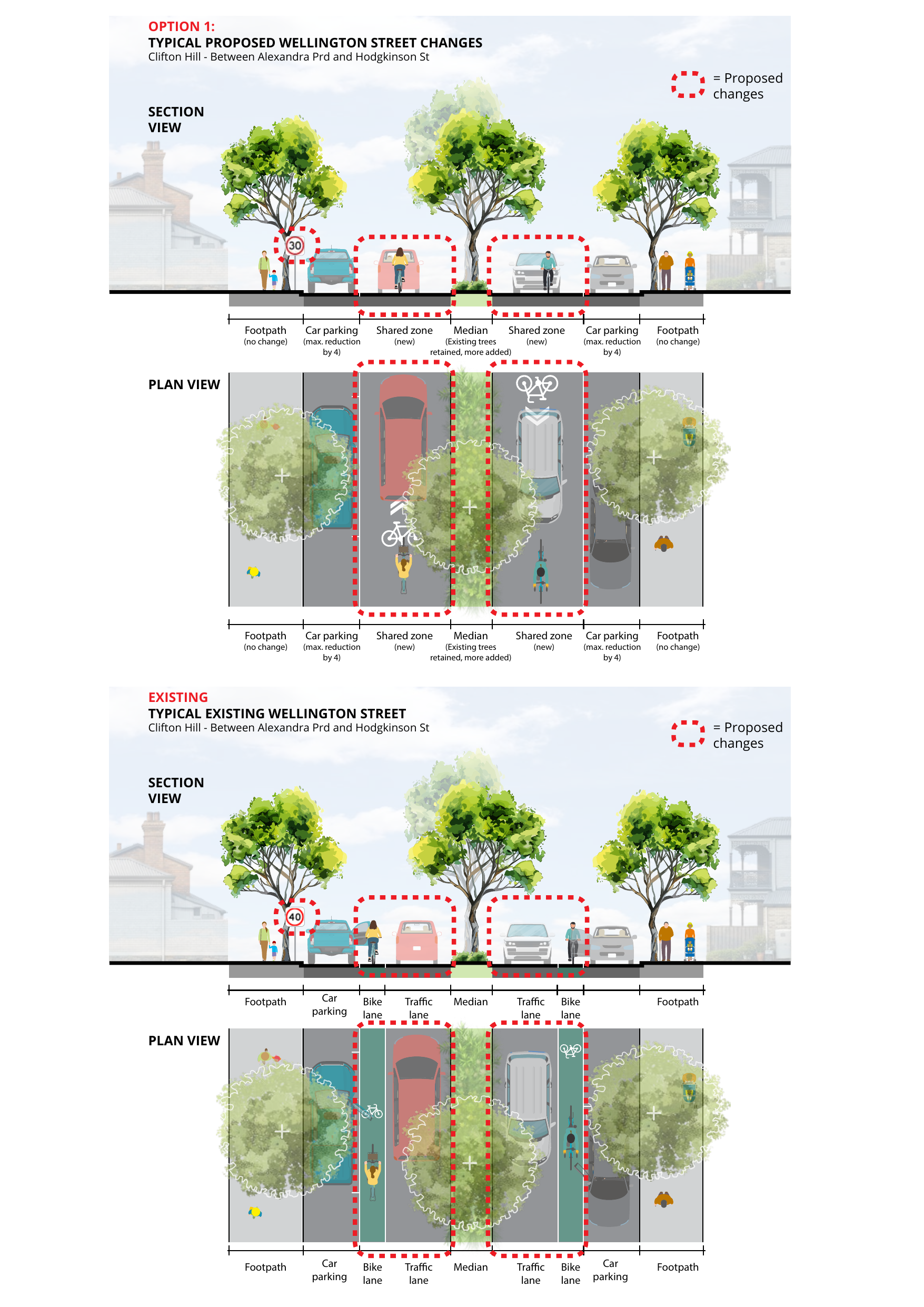
Alexandra Parade to Hodgkinson Street (southern sub-section)
This stretch includes the Clifton Hill Primary School gate.
| Option 1: Shared Street | Option 2: Protected Lanes | |
|---|---|---|
| Cycling infrastructure | Shared street (also called “Bicycle Street” in council’s design documents); people on bikes and in vehicles share the space | Physically separated kerb lanes |
| Speed limit | Reduced from 40 to 30 km/h | No change (stays at 40 km/h) |
| Non-local traffic | Partial traffic barriers | No change |
The cross-section below shows the Option 1 changes; we don’t think Option 2 is a good option for the Clifton Hill section, as it keeps the non-local traffic and the 40 km/h speed limit, while adding fewer trees and removing far more parking.
Hodgkinson Street to Queens Parade (northern sub-section)
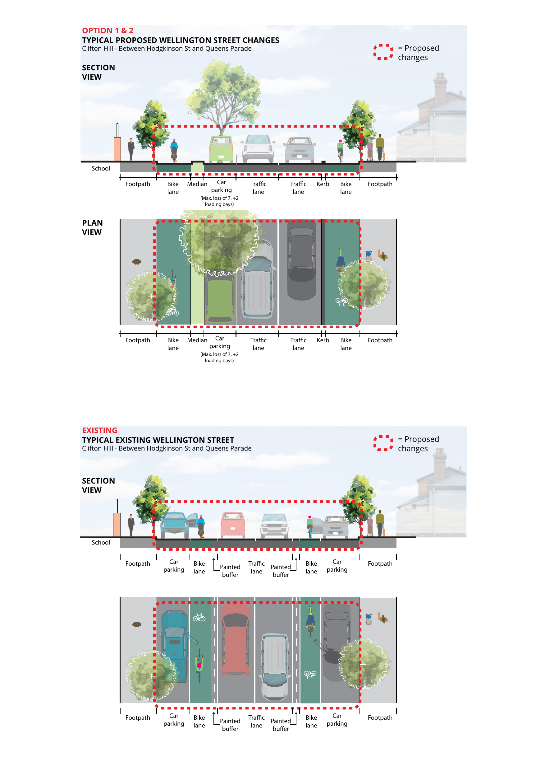
Both options include physically separated, protected cycling lanes on this stretch. This is where most of the physical change occurs and where almost all of the parking reduction falls. Queens Parade has abundant on-street parking immediately around the corner, so the practical loss of convenient parking in this part of the section is minimal. Parking near the school itself, on the southern sub-section, is largely unchanged under the shared street option.
What both options share
Regardless of which option proceeds, the Clifton Hill section includes:
- Raised zebra crossing outside Clifton Hill Primary School
- Pedestrian refuge islands
- Speed humps throughout, although the shared street provides more
- Hodgkinson Street roundabout: zebra crossings on Hodgkinson Street on either side of the roundabout
- Separated bike lanes near the Queens Parade intersection
- Asphalt surface maintenance and road condition upgrades
Option 1 also includes a continuous footpath treatment at the Hodgkinson Street roundabout (the paved area is raised to footpath level, so vehicles crossing it must slow significantly). Option 2 has the zebra crossings only.
Learn more
The PDF documents below contain detail that the main project page doesn’t surface prominently; many people miss them.
- YourSay Yarra: Building a safer Wellington Street - council’s main project page covering both stages
- YourSay Yarra: Wellington Street North - council’s project page for the Clifton Hill section, with interactive highlights of each specific treatment and links to more resources
- Yarra City Council news page: Building a safer Wellington Street - supplementary reports released after consultation closed, including the road safety audit, socio-economic analysis, and Stantec traffic calming options report
- Concept design drawings (PDF) - detailed street-level plans showing traffic barriers, new trees, pinch points, and intersection treatments for all options; look for Option 1 (labelled “Bicycle Street” in council’s documents)
- Traffic circulation plan (PDF) - shows how local access continues to work with the barriers in place
Stay in the loop as the project moves forward. Council voted on 12 May. The next decisions are what officers design, what the consultation on traffic control measures delivers, and which items are deemed feasible. We'll update you when your voice will count.
We also post updates on Instagram at @nicerwellingtonstreet.
Collingwood section: Johnston Street to Alexandra Parade
The Collingwood section (council’s Stage 3) is separate, with its own two options. Both options include a 30 km/h speed limit and traffic barriers that reduce non-local traffic.
- Option 1 (Shared Street): removes 10 of 81 bays, retains all 19 existing trees and adds 15 new ones
-
Option 2 (Painted Bike Lanes): removes 12 of 81 bays, results in a net loss of 7 trees from the existing 19
- YourSay Yarra: Wellington Street South - council’s project page for the Collingwood section
- Concept design drawings (PDF) - detailed street-level plans for all options across both stages
- Traffic recirculation plan — Option 2 (PDF) - shows how traffic is redirected under Option 2
Cost
The shared street option (Option 1) is significantly cheaper to build than the separated lanes option (Option 2), because it requires less reconstruction of the road surface and kerbing, and it delivers more: the 30 km/h limit, traffic barriers, and additional tree canopy that Option 2 does not include.
Council’s active travel programme is partly funded through the Victorian Congestion Levy, a state government charge on CBD car parking operators that funds cycling and walking projects across Melbourne. The total project cost for both stages is less than 1% of council’s annual budget.
Part of the state cycling network
Wellington Street is a C1 Primary Route in Victoria’s Strategic Cycling Corridors network, the highest classification. C1 routes connect the central city with Metropolitan Activity Centres and National Employment and Innovation Centres across metropolitan Melbourne. Both the project and the options have been assessed against that designation.